


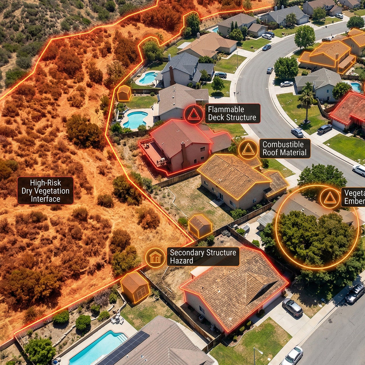
Hidden property-level hazards trigger catastrophic loss
Standard, surface-level risk assessments overlook critical boundary details, changing flood zones, and local regulatory shifts. These micro-level blind spots leave your organization completely unprotected against sudden claims, defaults, and regulatory penalties.

The new standard in portfolio risk management
Cotality empowers insurers, lenders, and investors to assess risk with peace of mind. By combining precise parcel-level data, deep property attributes, and real-time municipal signals, we replace outdated models with a dynamic, proactive view of your entire portfolio exposure. Protect your assets, optimize your underwriting, and price risk with absolute confidence.
Build a resilient, data-driven portfolio
Assess climate & environmental hazard
Overlay precise parcel boundaries with terrain and environmental data to accurately underwrite and price exposure to floods, wildfires, and extreme weather.
Ensure regulatory & zoning compliance
Track real-time changes in land use, building codes, and municipal planning to avoid costly compliance violations or stranded assets.
Accelerate underwriting & due diligence
Automate risk assessments by feeding our comprehensive property dataset directly into your models, speeding up policy issuance without sacrificing accuracy.
Protect financial investments
Monitor your portfolio for early warning signs of municipal distress, shifting property values, or nearby structural hazards before they impact your bottom line.
Foundations of risk intelligence
Backed by our enterprise-grade data architecture, engineered to plug directly into your proprietary hazard and underwriting models.

Precision at the parcel boundary, not the ZIP code
Traditional risk models often rely on broad ZIP-code or block-level data, which can treat every property in an affected area the same. This can lead to inaccurate pricing, missed opportunities, and unexpected exposure. Cotality delivers parcel-level risk intelligence, helping you see where a property boundary ends, and a hazard zone begins so you can make more accurate underwriting, pricing, and investment decisions.
FAQ
How granular is your spatial data for hazard modeling?
Can I integrate this data directly into our existing underwriting platform?
Can I monitor my existing portfolio for emerging risks over time?
How can we help you?
Let's get this conversation started! Our team is here to provide you with more information and answer any questions you may have.
Trying to reach us by phone?
Get in touch with our sales team at (866) 774-3282. We're here Monday to Friday from 7 a.m. to 5 p.m. CT.
Looking for support?
Visit our dedicated support page to find support for all our products.