


Overview

Texas consistently ranks number one in terms of states with the greatest number of homes impacted by roof shingle-shattering hail. In 2025, damaging hail fell on more than 235,000 properties, according to Cotality’s 2026 Severe Convective Storm Report.
That made last season a break-out year for hail. But understanding the impact of these storms requires a more granular view than the broad public warnings that National Weather Service (NWS) and the National Oceanic and Atmospheric Administration (NOAA) issue. While these atmospheric models are excellent for understanding a system's potential severity ahead of time, these reports lack detail about what actually happened after the fact.
For that type of insight, a forensic approach is required.
See the difference in forensic modeling
June 1, 2025, was a significant day for the Dallas-Fort Worth area in terms of hail to home impact. On that day, a single storm traveled across Dallas-Fort Worth and dropped hailstones up to 3 inches in diameter.
After the storm, the Storm Prediction Center (SPC) released its storm report for the day. Look at the mass of green dots around Dallas-Fort Worth in the map below. There were 20 hail reports in the area, eight of which were considered severe (with hail greater than 2 inches).
NOAA daily storm report captures hail storms
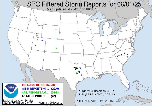
Data source: National Oceanic and Atmospheric Administration, 2026
According to the storm report, hail fell across 13 Texas counties including:
- Dallas County
- Johnson County
- Palo Pinto County
- Parker County
- Tarrant County
According to the U.S. Census Bureau’s Vintage 2024 Population and Housing Unit Estimates and the American Community Survey (ACS), there are more than 2 million homes across those counties.
In other words, if insurers covering the Dallas-Fort Worth area were to rely solely on public reports from the Storm Prediction Center, they would have been preparing to respond to potential damage across an area greater than 5,000 square miles. And if you were the chief claims officer (CCO) at one of these property insurance carriers, you need to answer questions like: How many policy holders do we have in this area? What is the impact to our portfolio? Who do we contact to initiate the claims process? How do we which homes were most likely impacted by small or large hail?
Unfortunately, there is no way to know for sure from this data alone. But a forensic approach could answer all these questions.
The Sherlock Holmes of severe weather impacts
Forensic radar analysis uses dual-polarization data to measure both the horizontal and vertical dimensions of a storm and then model precise, accurate footprints of any hailstorm in near real-time. The technology reconstructs 3D models that are so specific that they can distinguish the shape of a falling raindrop from the tumbling motion of a hailstone.
If we look at forensic output of the exact same June 1 storm, a much clearer and more detailed picture is revealed (Figure 2).
According to Cotality’s Weather Forensics™ there were 222,545 residential properties within the hail swath boundary that were potentially impacted. That is a lot more precise than 2 million.
A view of hail swaths from Cotality's Weather ForensicsTM
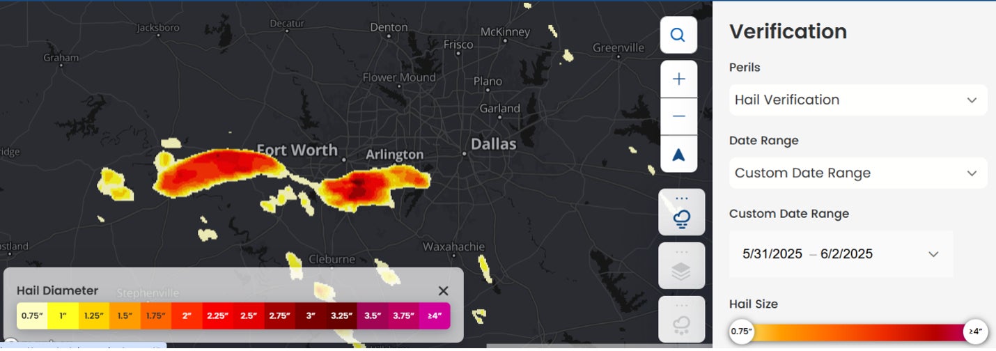
Data source: Cotality, 2026
Instead of generating broad alerts, forensic radar provides extreme precision — verifying exactly what size hail fell at a specific GPS coordinate. This hyper-local dataset reveals the exact hail patterns that can devastate one roof while leaving a neighboring property entirely untouched. These models can also differentiate between different sized hail that occurs during the same storm. Unlike with other verification methods, the forensic radar approach can distinguish the hail impact difference between neighboring structures.
What can you do with forensic hail verification?
Answers are essential to understand portfolio impacts in the wake of a severe weather event. The granular focus weather forensics provides not only optimized resource allocation but serves as a tool for loss confirmation, ensuring reported claims align perfectly with recorded atmospheric data at the specific location.
In an era of increasing volatility, the adoption of forensic radar analysis has become a necessity. This precise, virtual verification empowers insurers to mobilize resources accurately and support homeowners before a local disaster causes systemic delays. It is no longer just about seeing the storm coming; it is about personalizing recovery strategies long before policyholders even realize they need help.
