


Overview

Update: April 7, 2026
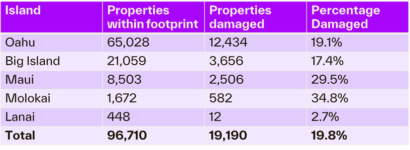
Cotality analyzed the flood footprint of the Kona Low and assessed the resulting property damage across the state. Cotality’s research indicates that of the 96,710 properties located within the storm’s flood footprint, nearly 20% sustained damage. The flood footprint included properties across multiple islands:
• 65,028 on Oahu
• 21,059 on the Big Island
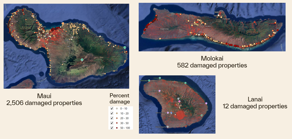
• 8,503 on Maui
• 1,672 on Molokai
• 448 on Lanai
Figure: Total number of properties within the flood foodprint on Oahu and Big Island
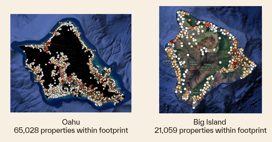
Data source: Cotality, 2026
Figure: Total number of properties within the flood footprint on Maui, Molokai, and Lanai
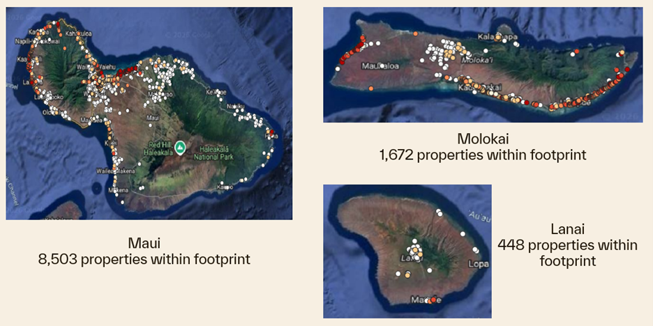
Data source: Cotality, 2026
Further analysis revealed that the flood damaged a total of 19,190 properties. Oahu sustained the heaviest impact with 12,434 damaged properties. The storm also damaged 3,656 properties on Big Island, 2,506 on Maui, 582 on Molokai, and 12 on Lanai.
Figure: Total number of properties damaged and their percentage damage within the flood footprint on Oahu and Big Island
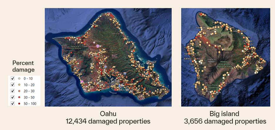
Data source: Cotality, 2026
Figure: Total number of properties damaged and their percentage damage within the flood footprint on Maui, Molokai, and Lanai
Data source: Cotality, 2026
Figure: Comparing the total number of properties within the flood print and the total number of properties damaged throughout the islands
Data source: Cotality, 2026
To better understand the cause of the extensive structural impact, we analyzed the first floor height (FFH) of the properties. Cotality data shows that approximately 62% of residential properties in the affected areas have a FFH between 1 foot and 1.5 feet. Because most of these homes are built relatively low to the ground, they are highly susceptible to interior water intrusion.
Floodwater only needs to rise slightly more than a foot to breach the main living spaces of these properties. This low structural elevation is a key reason why the storms caused such extensive structural impact, ultimately damaging 19,190 properties across the islands.
To validate these findings, Cotality evaluated our 2D hydrodynamic models against U.S. Geological Survey (USGS) gauge data, demonstrating exceptional accuracy across the state. Comparisons between the models and physical gauges include:
• Kalihi Stream near Honolulu, Oahu: The USGS gauge measured 10.4 feet, and the Cotality model estimated 10.5 feet
• Honouliuli Stream at H-1 Freeway near Waipahu, Oahu: The USGS gauge measured 9 feet, and the Cotality model estimated 9.2 feet
• Kawela Gulch near Moku, Molokai: The USGS gauge measured 13.43 feet, and the Cotality model estimated 13.28 feet
• Wailuku River at Iao Valley Road, Maui: The USGS gauge measured 13.51 feet, and the Cotality model estimated 13.32 feet
Cotality will continue to monitor the impact of this event.
Update: March 23, 2026
Between March 19 and 22, 2026, a second, weaker storm affected the state, striking ground already saturated by the previous week’s severe rainfall. This back-to-back pattern produced very high cumulative totals, with parts of Maui recording more than 46 inches of rain during the March 10–16 storm alone, and Honolulu breaking a daily rainfall record for March 13 that had stood since 1951.
The intense precipitation also triggered a critical infrastructure emergency on March 20, when the roughly 120-year-old Wahiawā Dam on Oʻahu was closely monitored amid rising water levels, prompting the mandatory evacuation of about 5,500 residents in Haleʻiwa and Waialua because of the risk of failure.
While the Wahiawā Dam evacuation orders were lifted on March 22 as water levels stabilized, significant damage persists across the islands, including storm damage in South Maui and a wastewater overflow in West Maui.
As of March 23, the system had begun to pull away, allowing for a return toward more typical trade wind conditions; however, some schools remained closed for damage assessments and repairs, and officials continued to warn that saturated ground could still contribute to localized flooding and landslide hazards.
Cotality will continue to monitor the impacts of this event.
Update: March 17, 2026
Hawaii was impacted by a significant multi-day Kona low from March 10 to 16, with another wetter pattern possible later in the week. A Kona low is a subtropical cyclone that significantly disrupts the typical trade wind pattern, typically resulting in prolonged heavy rain, flash flooding, and damaging winds.
The March 2026 Kona low brought prolonged, torrential rainfall across Hawaii. Meteorologists recorded repeated bands of heavy rain and thunderstorms, with 5 to 10 inches over much of the state and 15 to 25 inches in parts of Maui and the Big Island, with locally higher totals above 30 inches. The storm produced damaging wind gusts in the 60 to 75 mph range, with local gusts above 100 mph on the Big Island.
The multi-day storm severely impacted people, property, and critical infrastructure across the state. Widespread flash floods inundated residential neighborhoods, overwhelmed drainage systems, and caused significant structural damage to local roadways. Commercial operations also faced significant interruptions, as flooding and power outages forced many businesses to shutter their doors and suspend services.
First responders have conducted multiple water rescues, and as of March 16, thousands of residents remain without power as crews clear downed trees and debris. State officials are urging residents to avoid travel as ongoing rain continues to threaten already weakened infrastructure.
Maui has sustained some of the heaviest damage. All of South Kihei Road was closed due to heavy flooding on March 13, and on March 16, South and North Kihei Road remained impassable at several points.
Figure: Map of Cotality Flood Risk Score in area surrounding South Kihei Road in Maui, Hawaii
.png)
Data source: Cotality, 2026
Figure: Map of Cotality Flash Flood Risk Score in area surrounding South Kihei Road in Maui, Hawaii
.png)
Data source: Cotality, 2026
It’s important to note that a home can be located outside a designated flood zone with a low flood risk score, while still facing extreme risk of flash flooding. Federal Emergency Management Agency (FEMA) flood maps do not account for flash flood risk, which can leave property owners underinsured and underprepared.
When comparing this storm to past atmospheric events, the current system echoes the destructive December 2021 Kona low. Both the March 2026 and December 2021 events were damaging Kona lows that caused heavy rain, flooding, road closures, and power outages.
Cotality will continue to monitor the impacts of this event.
