Overview

South-central Texas endured a multi-day bout of dangerous weather as a slow-moving storm system produced catastrophic flash flooding across the Hill Country and spun up a confirmed tornado on the Northwest Side of San Antonio. The National Weather Service issued flash flood emergencies for Kerr, Kendall, and Uvalde counties, including the communities of Kerrville, Ingram, Hunt, Center Point, and Comfort, as rising water forced evacuations, water rescues, and road closures on Wednesday and Thursday, July 15 and 16, 2026. The flooding struck the same region and the same waterway affected by the destructive July 2025 Guadalupe River flood, one of the most damaging flood events in the recent history of the Texas Hill Country.
Meteorological background
A slow-moving system drew abundant tropical moisture into the region and stalled over the Edwards Plateau and western Hill Country, producing repeated rounds of heavy rain over already saturated ground. The National Weather Service reported that parts of Uvalde County recorded up to 16 inches of rain, and forecasters warned that storm total rainfall could reach 10 to 20 inches, with isolated amounts potentially exceeding 30 inches. The NOAA Weather Prediction Center placed portions of the region under its highest level of excessive rainfall risk. The same unstable, moisture-rich environment supported strong thunderstorms capable of producing tornadoes closer to the Interstate 10 corridor.
Tornado damage in northwest San Antonio
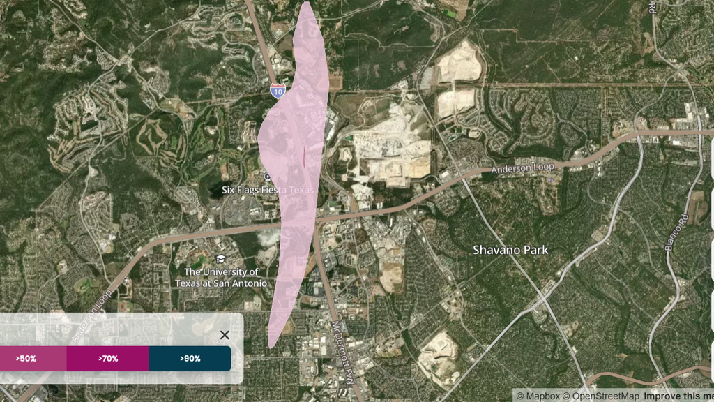
The National Weather Service confirmed that an EF-1 tornado with estimated peak winds of 100 mph touched down around 7:50 a.m. on Wednesday, July 15, in northwest Bexar County.
Figure: Map of tornado damage probability in San Antonio, Texas
Data source: Cotality Insight™, 2026
The tornado tracked through a developed part of the San Antonio metropolitan area, moving near the University of Texas at San Antonio, crossing Interstate 10, and reaching The Rim shopping center. Local officials reported that the tornado damaged structures, with the most significant structural damage occurring at an apartment complex near UTSA Boulevard, where the roof was torn away and several upper-floor units were damaged. Storefronts at The Rim, including a movie theater and several restaurants, also sustained damage.
Impacts to communities and infrastructure
The Guadalupe River at Kerrville surged to catastrophic levels, reaching a stage of roughly 34 feet, with the National Weather Service and local officials reporting that the river rose more than 30 feet within a few hours. Kerrville officials ordered residents to shelter in place and urged those in flood-prone areas to move to the highest levels of their homes. Emergency crews conducted dozens of water rescues, and reporting indicated that more than 75 people had been rescued from high water. Floodwaters damaged homes and property along rural roads such as County Road 40, entered structures in low-lying areas, and prompted the closure of numerous roads, including portions of Highway 50.
Historical context and implications for stakeholders
For the insurance industry, the event underscores the challenge of pricing and managing repeat inland-flood losses within a single, densely exposed watershed.
"Seeing catastrophic flooding return to the same stretch of the Guadalupe River within roughly a year is a stark reminder that flood risk is persistent and repetitive, not a once-in-a-generation event," said Maiclaire Bolton Smith, VP of insurance market insights at Cotality. "So much of this exposure sits outside mapped floodplains and outside standard homeowners policies, which widens the protection gap. Insurers need granular, property-level data and modeling to understand where the water could go and what it could cost."
Cotality will continue to monitor this event and may provide updates when available.